Technology
Making invisible dangers visible


Civilian mine clearance is dangerous, slow, and expensive. findmine develops new sensors that safely detect explosive remnants of war like mines or unexploded ordnance from above, accurately and without requiring people to enter the danger zone. The findmine sensor technology includes wide-area Ground-Penetrating Synthetic Aperture Radar (GPSAR), specialized Linear Scanning Radar (LSCAN) for path exploration and monitoring, and pinpoint metal detection. Mounted on Unmanned Aircraft Systems (UAS), our sensors reach their target areas and operate day and night – without putting people at risk.
The vision of findmine is a scalable, automated mine detection system that works like modern mapping, quickly opening up new perspectives for affected areas, in terms of safety, mobility, and agriculture.
The development team at findmine is working on airborne sensor systems capable of detecting hidden threats such as unexploded ordnance and landmines, which are buried in soil or concealed by vegetation. These systems are not yet known or available outside academic research. The development builds on the findings of leading research partners in Germany and Switzerland and is being advanced by a dedicated team of specialists at findmine – turning scientific insight into a practical breakthrough.
At the core of the system is FM-GPSAR, a UAV-based Ground-Penetrating Synthetic Aperture Radar, specifically developed for wide-area, non-invasive aerial surveying of suspected hazardous zones.
It is complemented by FM-LSCAN, a system designed for targeted scanning of roads and pathways from the air or from vehicles. FM-LSCAN uses a combination of digital beamforming and GPSAR.
To confirm detections and eliminate false alarms, FM-METAL, a highly sensitive metal detector with rotating coils, is being developed. It can also be operated by a UAS.
Under the name FM-TEST, findmine builds and continuously refines dedicated test environments, realistic surrogates, and structured evaluation processes. Mine-detection sensors must perform reliably under highly diverse conditions, from changing soils and vegetation to varying moisture and mine types.
FM-GPSAR
Ground-Penetrating Synthetic Aperture Radar

Using its FM-GPSAR system, findmine is introducing a unique GPSAR technology. An autonomous unmanned aircraft system flies over suspected areas and captures radar data from multiple perspectives to generate precise subsurface images – reaching depths of up to 50 cm, even beneath dense vegetation. The system can detect mines and unexploded ordnance that are fully hidden underground or in overgrowth, including those with low or no metal content.
Unlike cameras, metal detectors, or magnetometers, FM-GPSAR operates from a safe altitude and delivers high-resolution radar images for the automated marking of hazardous zones – contact-free, fast, and scalable.


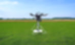
figure 1:
FM-GPSAR UAS in flight
All electronic components of the GPSAR system are integrated into the sensor pod mounted beneath the drone.

figure 2:
Sensor pod and antenna


figure 3:
Microwave tomography
Tomographic principle, trajectory and volume resolution

figure 4:
Operating principle of microwave tomography
FM-GPSAR uses synthetic aperture radar to collect radar echoes from different positions along the flight path. These signals are processed using tomographic algorithms to reconstruct high-resolution, three-dimensional images of subsurface structures.

The basic principle of GPSAR
The GPSAR UAS is equipped with a side-looking ground-penetrating radar sensor. It follows a predefined flight path autonomously, collecting radar data from multiple perspectives. After landing, the data is processed by advanced algorithms on a high-performance computer to generate high-resolution tomographic depth images – typically achieving 5 cm horizontal and 1 cm vertical resolution. Specialized detection algorithms then identify and mark suspicious points within these images.
FM-GPSAR system components
The FM-GPSAR system includes:
-
GPS rod for precise georeferencing using surveyed ground markers
-
Camera-equipped UAS for initial site inspection
-
The FM-GPSAR UAS itself
-
GPS base station for Real-Time Kinematic (RTK) correction
-
Custom-built field processing unit developed by findmine for on-site data processing
-
Laptop for system operation and live monitoring
-
Accessories such as remote controls, batteries, and chargers
Software and offline operation
All software modules provide a web-based user interface and can be run via Internet or in a local network in the field.
The available modules include:
-
Generation of orthophotos and surface models
-
Flight planning
-
Data localization and preprocessing
-
Tomography-like GPSAR processing
-
Detection analysis
Typical measurement sequence
-
Georeferencing of terrain markers using the real-time kinematic data of the base station and the GPS rod
-
Initial site reconnaissance with the camera-equipped UAS, as well as the creation of orthophotos and 3D surface models
-
Flight planning and upload to the FM-GPSAR UAS
-
Automated radar survey flight
-
Data transfer to the custom-built Field Processing Unit (FPU) after each flight
-
Computation of depth images with localization accuracy of ±5 cm
-
Identification of suspicious objects via detection algorithms
-
Overlay of results onto the orthophoto for visual evaluation
-
Export of target lists and suspicious points with RTK accuracy for precise mapping
FM-LSCAN
Linear Scanning Radar for roads, paths and narrow passages

Many mined areas are located along roads, trails, or even between buildings – environments where wide-area GPSAR methods may reach their limits. The FM-LSCAN system was specifically developed for such linear structures. It scans narrow strips from low altitudes and detects suspicious objects directly beneath the surface – even near walls or obstacles. The Linear Scanning Radar can also be mounted on all-terrain vehicles, making it ideal for areas where UAS deployment is not possible or safe.
Targeted detection along paths
The GPSAR system requires multiple viewing perspectives for tomographic analysis – meaning it must also fly outside the target zone. In linear or narrow environments, such as roads, paths, or also areas between buildings – this is often impractical or inefficient. LSCAN stands for Linear Scanning Radar – a specially configured GPSAR with an antenna array approximately 2 meters wide. It generates depth data in a strip directly beneath the flight path and requires no perspectives from outside the flight path.
Application and advantages
-
Ideal for linear applications: roads, paths, trails, avenues
-
Scans at altitudes of 1–3 meters, even near walls or obstacles
-
Measures up to 0.5 meters near structures using additional side-mounted sensors
-
Adaptable for use on vehicles such as unmanned ground systems with booms or masts
-
Extreme sensitivity to changes: for example, if booby traps or mines are planted overnight
Limitations
-
Lower area throughput compared to FM-GPSAR
-
Higher hardware complexity
-
Requires high-performance UAS platforms for flight-based use
-
Not suitable for all types of terrain
FM-METAL
Verification of radar-detected targets
Radar can detect many things – but not everything is dangerous.To avoid costly misjudgments, findmine uses FM‑METAL: A metal detector mounted on a UAS that verifies suspicious spots identified by radar – precisely, close to the ground, and with high confidence. Even the smallest metal traces can be detected. To rule out false alarms, suspected areas are checked with a pinpoint metal detector.
Metal-content verification of radar-detected targets
Ground-Penetrating Synthetic Aperture Radar Systems like FM-GPSAR and FM-LSCAN deliver high-resolution images of potentially dangerous anomalies. However, natural objects such as rocks, plants, or animal burrows can produce reflections similar to those of mines. To eliminate such false alarms, FM-METAL was developed.
The system consists of a UAS equipped with a highly sensitive metal detector based on rotating coils. The UAS flies to suspicious coordinates and performs a near-landing maneuver, allowing the sensor to measure close to the ground above the target area.
Characteristics
-
Detects the smallest metal parts (e.g., 10 mm sphere) at depths of up to 30 cm
-
Working area approximately 50 cm in diameter per detection
-
A measurement point takes less than 20 seconds, allowing for many checks per flight
-
High accuracy, especially for anti-vehicle mines and IEDs with low metal content
FM-TEST
Realistic validation under operational conditions

Sensor technology alone is not enough. For FM-GPSAR, FM-LSCAN, and FM-METAL to function reliably in the field, they must be tested under realistic conditions – with real terrain, real disruptions, and typical sources of error.
FM-TEST provides such validation environments: with soil variations, vegetation, humidity, uneven ground, and known reference objects placed in the subsurface. This is the only way to minimize false alarms and confidently identify real threats – before deploying the systems in at-risk regions.
The operating conditions for mine detection sensors are extremely diverse. In addition to a wide variety of mine types, there are countless combinations of soil types, surface structures, vegetation, biological traces, and varying moisture levels. This results in virtually unlimited deployment scenarios. To develop practical, field-ready solutions, comprehensive and multi-layered testing is essential. Under the name FM-TEST, findmine is building and continuously refining dedicated test environments, realistic dummies, and structured evaluation processes. findmine maintains two test sites: one close to its German headquarters and one located in an arid zone in Portugal.
The goal of FM-TEST
With FM-TEST, findmine has created a platform for practical, real-world system validation.
To achieve this:
-
Test environments with interchangeable soil profiles and structured zones are built
-
Dummy objects with defined signatures (metallic, non-metallic, empty, fragmented, etc.) are used
-
Scenarios with typical interferences are simulated (e.g., molehills, roots, trash, stones)
-
Processes for result validation are established – including repeatability, comparability and referencing
Benefits for development and deployment
-
Avoidance of costly false alarms in the field
-
Adaptation and training of detection algorithms
-
Preparation for specific terrains in operational regions
-
Training of personnel under realistic conditions
Testing sites
Dedicated facilities in Germany and Portugal

Sites for testing and validation
findmine operates dedicated facilities, including test-field dummies and controlled reference conditions that simulate real-world scenarios. Our structured data collection enables reliable performance evaluations of all systems.
Test field
Gannertshofen, Germany


Test field
Freixo do Meio, Portugal


Indoor test facility
University of Applied Science
Ulm, Germany


Application video
Field tests in Ukraine
Linking publications
Scientific papers on the findmine system
Public presentation of findmine
findmine gGmbH and Project findmine
findmine project publications
Time domain projection for real-time side-looking GP-SAR
by Johannes Schlichenmaier, Bernd Arendt, Winfried Mayer
in doctoral thesis (pdf); 2025
Radar UAVs for safe landmine detection: Research results by Bernd Arendt flow into start-up
by Klaus Sedlacek (Autor und Herausgeber)
in Klaus-Sedlacek.de; 2025
Radar UAVs for safe landmine detection: Research results by Bernd Arendt flow into start-up
by Franziska Lampert (Press, Marketing and Communications THU)
in idw - Informationsdienst Wissenschaft; 2025
Reducing the false alarm rate in landmine detection using ground-penetrating radar
by Bernd Arendt
in OPARU; 2025
Environmental influences on the detection of buried objects with a ground-penetrating radar
by Bernd Arendt, Michael Schneider, Winfried Mayer, Thomas Walter
in MDPI; 2024
Detection of objects below uneven surfaces with a UAV-based GPSAR
by Alexander Grathwohl, Bernd Arendt, Timo Grebner, Christian Waldschmidt
in IEEE Transactions on Geoscience and Remote Sensing; 2023
Wavelet transform analysis for a continuous wave metal detector for UAV applications
by Ivan Romero, Thomas Walter, Simon Mariager
in IEEE International Geoscience and Remote Sensing Symposium; 2023
Depth analysis for continuous wave metal detector for UAV applications
by Ivan Romero, Thomas Walter, Simon Mariager
in IEEE International Geoscience and Remote Sensing Symposium; 2023
Interference effects of shallow buried targets on a GPR
by Bernd Arendt, Thomas Walter, Winfried Mayer
in IEEE International Geoscience and Remote Sensing Symposium; 2023
Buried target detection with a UAV-based GPSAR system using a Circle-Hough Transformation
by Bernd Arendt, Thomas Walter, Winfried Mayer
in IEEE International Geoscience and Remote Sensing Symposium; 2023
by Hansjörg Eberle, Frank Masche
in detektor.fm; 2022
Influence of vegetation on the detection of shallowly buried objects with a UAV-based GPSAR
by Bernd Arendt, Alexander Grathwohl, Christian Waldschmidt, Thomas Walter
in IEEE International Geoscience and Remote Sensing Symposium; 2022
Influence of soil moisture on the detection of buried objects using an airborne GPSAR
by Alexander Grathwohl, Bernd Arendt, Thomas Walter, Christian Waldschmidt
in International Microwave Symposium; 2022
Performance analysis and simulation of a continuous wave metal detector for UAV applications
by Ivan Romero, Thomas Walter, Simon Mariager
in IEEE International Geoscience and Remote Sensing Symposium; 2022
Taking a look beneath the surface: multicopter UAV-based ground-penetrating imaging radars
by Alexander Grathwohl, Michael Stelzig, Julian Kanz, Patrick Fenske, Andreas Benedikter, Christina Knill
in IEEE Microwave Magazine; 2022
An experimental study on airborne landmine detection using a circular synthetic aperture radar
by Markus Schartel, Ralf Burr, Rik Bähnemann, Winfried Mayer, Christian Waldschmidt
in arXiv; 2020
Airborne tripwire detection using a synthetic aperture radar
by Markus Schartel, Ralf Burr, Winfried Mayer, Christian Waldschmidt
in IEEE Geoscience and Remote Sensing Letters; 2020
UAV-based polarimetric synthetic aperture radar for mine detection
by Ralf Burr, Markus Schartel, Winfried Mayer, Thomas Walter, Christian Waldschmidt
in IEEE International Geoscience and Remote Sensing Symposium; 2019
Position acquisition for a multicopter-based synthetic aperture radar
by Markus Schartel, Rik Bähnemann, Ralf Burr, Winfried Mayer, Christian Waldschmidt
in International Radar Symposium; 2019
Revisiting boustrophedon coverage path planning as a generalized traveling salesman problem
by Rik Bähnemann, Nicholas Lawrance, Jen Jen Chung, Michael Pantic, Roland Siegwart, Juan Nieto
in FSR Conference; 2019
Video Revisiting boustrophedon coverage path planning as a generalized traveling salesman problem
by ETH Zürich
in FSR Conference; 2019
A comparison of ground-based and airborne SAR systems for the detection of landmines, UXO and IEDs
by Andreas Heinzel, Markus Schartel, Ralf Burr, Rik Bähnemann, Eric Schreiber, Markus Peichl, Christian Waldschmidt
in SPIE Defense + Commercial Sensing; 2019
Design of a broadband FMCW GPR for mine detection and the influence of vegetation
by Ralf Burr, Markus Schartel, Winfried Mayer, Thomas Walter, Christian Waldschmidt
in German Microwave Conference; 2019
findmine – UAV in humanitarian operations
by Werner Mayr
in DVW-Seminar; 2019
UAV-based ground-penetrating synthetic aperture radar
by Markus Schartel, Ralf Burr, Winfried Mayer, Nando Docci, Christian Waldschmidt
in IEEE MTT-S International Conference on Microwaves for Intelligent Mobility; 2018
Radar-based altitude over ground estimation of UAVs
by Markus Schartel, Ralf Burr, Pirmin Schöder, Gilberto Rossi, Philipp Hügler, Winfried Mayer, Christian Waldschmidt
in German Microwave Conference; 2018
A multicopter-based method for ground-penetrating synthetic aperture radars
by Markus Schartel, Krishnendhu Prakasan, Philipp Hügler, Ralf Burr, Winfried Mayer, Christian Waldschmidt
in IEEE International Geoscience and Remote Sensing Symposium; 2018
Lightweight broadband antennas for UAV-based GPR sensors
by Ralf Burr, Markus Schartel, Winfried Mayer, Thomas Walter, Christian Waldschmidt
in European Radar Conference; 2018
A broadband UAV-based FMCW GPR and the influence of vegetation
by Ralf Burr, Markus Schartel, Patrick Schmidt, Winfried Mayer, Thomas Walter, Christian Waldschmidt
in IEEE MTT-S International Conference on Microwaves for Intelligent Mobility; 2018
Humanitarian demining – UAV-based detection of land mines
by Reinhard Gottwald, Nando Docci, Winfried Mayer
in FIG Working Week Helsinki; 2017